|
|
|||||||||||||||||
| Point ID: 6053 | Downloads | Plots | Site Data | Code: 7089 |
|
|
|||||||||||||||||
| Download | |
|---|---|
| Site Descriptor Information | Site Time Series Data |
| Link to all available data | |
| View: | Time Series | All |
| Units: | mm |
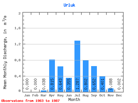
| Statistic | Jan | Feb | Mar | Apr | May | Jun | Jul | Aug | Sep | Oct | Nov | Dec | Annual |
|---|---|---|---|---|---|---|---|---|---|---|---|---|---|
| Mean | 0.00 | 0.00 | 0.04 | 0.81 | 0.64 | 0.35 | 1.29 | 0.80 | 0.65 | 0.40 | 0.09 | 0.00 | 0.38 |
| Standard Deviation | 0.00 | 0.00 | 0.05 | 0.55 | 0.60 | 0.40 | 2.75 | 0.62 | 0.48 | 0.24 | 0.09 | 0.01 | 0.23 |
| Min | 0.00 | 0.00 | 0.00 | 0.04 | 0.02 | 0.01 | 0.05 | 0.17 | 0.11 | 0.07 | 0.00 | 0.00 | 0.09 |
| Max | 0.00 | 0.00 | 0.17 | 2.07 | 2.28 | 1.75 | 14.00 | 2.86 | 1.98 | 1.00 | 0.43 | 0.03 | 0.99 |
| Coefficient of Variation | 1.29 | 0.68 | 0.93 | 1.13 | 2.14 | 0.78 | 0.74 | 0.61 | 1.05 | 2.63 | 0.61 |
 Return to R-Arctic Net Home Page