|
|
|||||||||||||||||
| Point ID: 6053 | Downloads | Plots | Site Data | Code: 7089 |
|
|
|||||||||||||||||
| Download | |
|---|---|
| Site Descriptor Information | Site Time Series Data |
| Link to all available data | |
| View: | Time Series | All |
| Units: | m3/s |
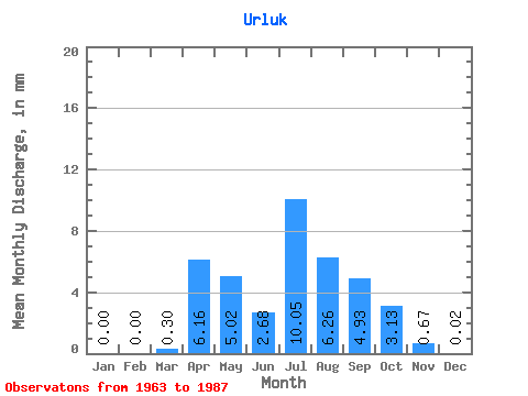
| Statistic | Jan | Feb | Mar | Apr | May | Jun | Jul | Aug | Sep | Oct | Nov | Dec | Annual |
|---|---|---|---|---|---|---|---|---|---|---|---|---|---|
| Mean | 0.00 | 0.00 | 0.29 | 6.16 | 5.02 | 2.69 | 10.05 | 6.26 | 4.93 | 3.13 | 0.67 | 0.02 | 34.94 |
| Standard Deviation | 0.00 | 0.00 | 0.38 | 4.15 | 4.68 | 3.03 | 21.46 | 4.87 | 3.63 | 1.91 | 0.70 | 0.05 | 21.23 |
| Min | 0.00 | 0.00 | 0.00 | 0.26 | 0.13 | 0.04 | 0.41 | 1.33 | 0.83 | 0.53 | 0.02 | 0.00 | 8.11 |
| Max | 0.00 | 0.00 | 1.33 | 15.64 | 17.80 | 13.22 | 109.31 | 22.33 | 14.96 | 7.81 | 3.25 | 0.23 | 90.75 |
| Coefficient of Variation | 1.29 | 0.68 | 0.93 | 1.13 | 2.14 | 0.78 | 0.74 | 0.61 | 1.05 | 2.63 | 0.61 |
 Return to R-Arctic Net Home Page