|
|
|||||||||||||||||
| Point ID: 6051 | Downloads | Plots | Site Data | Code: 7079 |
|
|
|||||||||||||||||
| Download | |
|---|---|
| Site Descriptor Information | Site Time Series Data |
| Link to all available data | |
| View: | Time Series | All |
| Units: | mm |
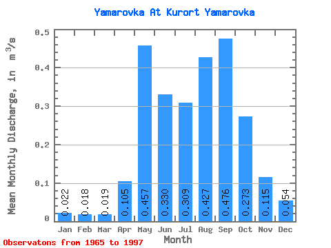
| Statistic | Jan | Feb | Mar | Apr | May | Jun | Jul | Aug | Sep | Oct | Nov | Dec | Annual |
|---|---|---|---|---|---|---|---|---|---|---|---|---|---|
| Mean | 0.02 | 0.02 | 0.02 | 0.10 | 0.46 | 0.33 | 0.31 | 0.43 | 0.48 | 0.27 | 0.12 | 0.05 | 0.24 |
| Standard Deviation | 0.02 | 0.02 | 0.02 | 0.08 | 0.23 | 0.23 | 0.24 | 0.30 | 0.33 | 0.15 | 0.06 | 0.03 | 0.10 |
| Min | 0.00 | 0.00 | 0.00 | 0.03 | 0.12 | 0.07 | 0.08 | 0.05 | 0.08 | 0.07 | 0.03 | 0.01 | 0.12 |
| Max | 0.06 | 0.05 | 0.06 | 0.33 | 0.90 | 1.04 | 1.10 | 1.27 | 1.48 | 0.62 | 0.24 | 0.12 | 0.44 |
| Coefficient of Variation | 0.88 | 0.93 | 0.99 | 0.74 | 0.49 | 0.71 | 0.77 | 0.71 | 0.70 | 0.56 | 0.51 | 0.59 | 0.40 |
 Return to R-Arctic Net Home Page