|
|
|||||||||||||||||
| Point ID: 6051 | Downloads | Plots | Site Data | Code: 7079 |
|
|
|||||||||||||||||
| Download | |
|---|---|
| Site Descriptor Information | Site Time Series Data |
| Link to all available data | |
| View: | Time Series | All |
| Units: | m3/s |
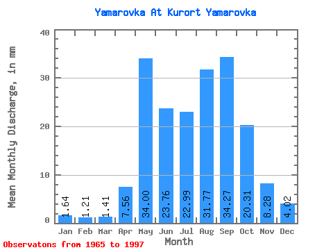
| Statistic | Jan | Feb | Mar | Apr | May | Jun | Jul | Aug | Sep | Oct | Nov | Dec | Annual |
|---|---|---|---|---|---|---|---|---|---|---|---|---|---|
| Mean | 1.61 | 1.19 | 1.41 | 7.57 | 34.03 | 23.74 | 22.95 | 31.78 | 34.26 | 20.30 | 8.26 | 4.01 | 210.25 |
| Standard Deviation | 1.41 | 1.10 | 1.39 | 5.60 | 16.82 | 16.79 | 17.60 | 22.66 | 23.94 | 11.37 | 4.23 | 2.39 | 83.03 |
| Min | 0.07 | 0.00 | 0.00 | 2.09 | 8.93 | 5.18 | 5.95 | 3.65 | 5.47 | 5.28 | 1.87 | 0.82 | 108.49 |
| Max | 4.76 | 3.59 | 4.24 | 23.76 | 66.95 | 74.88 | 81.83 | 94.47 | 106.56 | 46.12 | 17.28 | 8.93 | 382.23 |
| Coefficient of Variation | 0.88 | 0.93 | 0.99 | 0.74 | 0.49 | 0.71 | 0.77 | 0.71 | 0.70 | 0.56 | 0.51 | 0.59 | 0.40 |
 Return to R-Arctic Net Home Page