|
|
|||||||||||||||||
| Point ID: 597 | Downloads | Plots | Site Data | Code: 07AC007 |
|
|
|||||||||||||||||
| Download | |
|---|---|
| Site Descriptor Information | Site Time Series Data |
| Link to all available data | |
| View: | Time Series | All |
| Units: | mm |
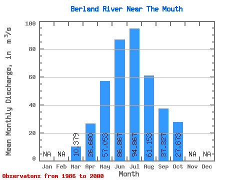
| Statistic | Jan | Feb | Mar | Apr | May | Jun | Jul | Aug | Sep | Oct | Nov | Dec | Annual |
|---|---|---|---|---|---|---|---|---|---|---|---|---|---|
| Mean | 10.38 | 26.68 | 57.05 | 86.87 | 94.87 | 61.15 | 37.33 | 27.87 | |||||
| Standard Deviation | 3.28 | 10.16 | 25.96 | 41.88 | 52.83 | 43.11 | 17.83 | 12.04 | |||||
| Min | 6.30 | 17.30 | 19.60 | 31.30 | 27.20 | 18.20 | 15.40 | 14.20 | |||||
| Max | 21.00 | 44.20 | 132.00 | 186.00 | 212.00 | 175.00 | 82.80 | 61.20 | |||||
| Coefficient of Variation | 0.32 | 0.38 | 0.46 | 0.48 | 0.56 | 0.70 | 0.48 | 0.43 |
 Return to R-Arctic Net Home Page