|
|
|||||||||||||||||
| Point ID: 597 | Downloads | Plots | Site Data | Code: 07AC007 |
|
|
|||||||||||||||||
| Download | |
|---|---|
| Site Descriptor Information | Site Time Series Data |
| Link to all available data | |
| View: | Time Series | All |
| Units: | m3/s |
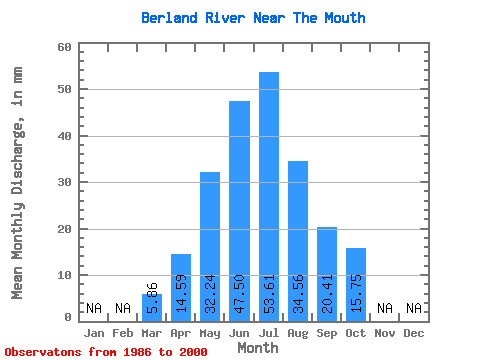
| Statistic | Jan | Feb | Mar | Apr | May | Jun | Jul | Aug | Sep | Oct | Nov | Dec | Annual |
|---|---|---|---|---|---|---|---|---|---|---|---|---|---|
| Mean | 5.86 | 14.59 | 32.23 | 47.50 | 53.60 | 34.55 | 20.41 | 15.75 | |||||
| Standard Deviation | 1.85 | 5.56 | 14.67 | 22.90 | 29.85 | 24.36 | 9.75 | 6.80 | |||||
| Min | 3.56 | 9.46 | 11.07 | 17.12 | 15.37 | 10.28 | 8.42 | 8.02 | |||||
| Max | 11.87 | 24.17 | 74.58 | 101.71 | 119.78 | 98.87 | 45.28 | 34.58 | |||||
| Coefficient of Variation | 0.32 | 0.38 | 0.46 | 0.48 | 0.56 | 0.70 | 0.48 | 0.43 |
 Return to R-Arctic Net Home Page