|
|
|||||||||||||||||
| Point ID: 5950 | Downloads | Plots | Site Data | Code: 1615 |
|
|
|||||||||||||||||
| Download | |
|---|---|
| Site Descriptor Information | Site Time Series Data |
| Link to all available data | |
| View: | Time Series | All |
| Units: | mm |
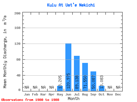
| Statistic | Jan | Feb | Mar | Apr | May | Jun | Jul | Aug | Sep | Oct | Nov | Dec | Annual |
|---|---|---|---|---|---|---|---|---|---|---|---|---|---|
| Mean | 13.21 | 120.97 | 89.14 | 71.55 | 50.09 | 13.08 | |||||||
| Standard Deviation | 12.56 | 56.45 | 31.82 | 26.91 | 24.59 | 2.23 | |||||||
| Min | 1.90 | 53.10 | 49.00 | 47.20 | 23.90 | 10.60 | |||||||
| Max | 28.90 | 200.00 | 145.00 | 130.00 | 103.00 | 16.20 | |||||||
| Coefficient of Variation | 0.95 | 0.47 | 0.36 | 0.38 | 0.49 | 0.17 |
 Return to R-Arctic Net Home Page