|
|
|||||||||||||||||
| Point ID: 5950 | Downloads | Plots | Site Data | Code: 1615 |
|
|
|||||||||||||||||
| Download | |
|---|---|
| Site Descriptor Information | Site Time Series Data |
| Link to all available data | |
| View: | Time Series | All |
| Units: | m3/s |
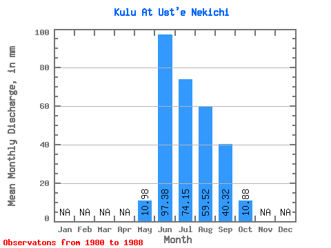
| Statistic | Jan | Feb | Mar | Apr | May | Jun | Jul | Aug | Sep | Oct | Nov | Dec | Annual |
|---|---|---|---|---|---|---|---|---|---|---|---|---|---|
| Mean | 10.98 | 97.38 | 74.13 | 59.51 | 40.32 | 10.88 | |||||||
| Standard Deviation | 10.45 | 45.44 | 26.46 | 22.38 | 19.80 | 1.86 | |||||||
| Min | 1.58 | 42.74 | 40.75 | 39.26 | 19.24 | 8.82 | |||||||
| Max | 24.04 | 160.99 | 120.59 | 108.12 | 82.91 | 13.47 | |||||||
| Coefficient of Variation | 0.95 | 0.47 | 0.36 | 0.38 | 0.49 | 0.17 |
 Return to R-Arctic Net Home Page