|
|
|||||||||||||||||
| Point ID: 5940 | Downloads | Plots | Site Data | Code: 1590 |
|
|
|||||||||||||||||
| Download | |
|---|---|
| Site Descriptor Information | Site Time Series Data |
| Link to all available data | |
| View: | Time Series | All |
| Units: | mm |
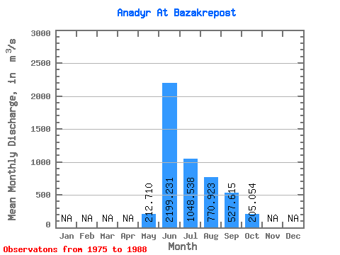
| Statistic | Jan | Feb | Mar | Apr | May | Jun | Jul | Aug | Sep | Oct | Nov | Dec | Annual |
|---|---|---|---|---|---|---|---|---|---|---|---|---|---|
| Mean | 212.71 | 2199.23 | 1048.54 | 770.92 | 527.62 | 205.05 | |||||||
| Standard Deviation | 189.82 | 621.17 | 510.38 | 305.96 | 281.78 | 136.92 | |||||||
| Min | 15.80 | 1130.00 | 367.00 | 250.00 | 173.00 | 56.80 | |||||||
| Max | 644.00 | 3130.00 | 2130.00 | 1300.00 | 1190.00 | 572.00 | |||||||
| Coefficient of Variation | 0.89 | 0.28 | 0.49 | 0.40 | 0.53 | 0.67 |
 Return to R-Arctic Net Home Page