|
|
|||||||||||||||||
| Point ID: 5940 | Downloads | Plots | Site Data | Code: 1590 |
|
|
|||||||||||||||||
| Download | |
|---|---|
| Site Descriptor Information | Site Time Series Data |
| Link to all available data | |
| View: | Time Series | All |
| Units: | m3/s |
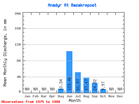
| Statistic | Jan | Feb | Mar | Apr | May | Jun | Jul | Aug | Sep | Oct | Nov | Dec | Annual |
|---|---|---|---|---|---|---|---|---|---|---|---|---|---|
| Mean | 10.34 | 103.46 | 50.96 | 37.47 | 24.82 | 9.97 | |||||||
| Standard Deviation | 9.23 | 29.22 | 24.81 | 14.87 | 13.26 | 6.66 | |||||||
| Min | 0.77 | 53.16 | 17.84 | 12.15 | 8.14 | 2.76 | |||||||
| Max | 31.30 | 147.24 | 103.52 | 63.18 | 55.98 | 27.80 | |||||||
| Coefficient of Variation | 0.89 | 0.28 | 0.49 | 0.40 | 0.53 | 0.67 |
 Return to R-Arctic Net Home Page