|
|
|||||||||||||||||
| Point ID: 5939 | Downloads | Plots | Site Data | Code: 1589 |
|
|
|||||||||||||||||
| Download | |
|---|---|
| Site Descriptor Information | Site Time Series Data |
| Link to all available data | |
| View: | Time Series | All |
| Units: | mm |
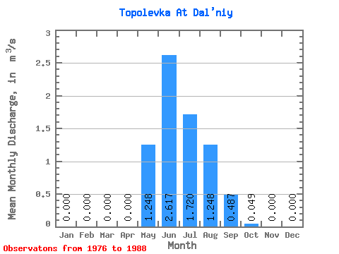
| Statistic | Jan | Feb | Mar | Apr | May | Jun | Jul | Aug | Sep | Oct | Nov | Dec | Annual |
|---|---|---|---|---|---|---|---|---|---|---|---|---|---|
| Mean | 0.00 | 0.00 | 0.00 | 0.00 | 1.25 | 2.62 | 1.72 | 1.25 | 0.49 | 0.05 | 0.00 | 0.00 | 0.62 |
| Standard Deviation | 0.00 | 0.00 | 0.00 | 0.00 | 0.61 | 1.35 | 1.32 | 0.81 | 0.41 | 0.04 | 0.00 | 0.00 | 0.26 |
| Min | 0.00 | 0.00 | 0.00 | 0.00 | 0.26 | 0.81 | 0.07 | 0.18 | 0.14 | 0.02 | 0.00 | 0.00 | 0.41 |
| Max | 0.00 | 0.00 | 0.00 | 0.00 | 2.11 | 4.73 | 4.67 | 2.64 | 1.42 | 0.16 | 0.00 | 0.00 | 0.91 |
| Coefficient of Variation | 0.49 | 0.52 | 0.77 | 0.65 | 0.84 | 0.89 | 0.41 |
 Return to R-Arctic Net Home Page