|
|
|||||||||||||||||
| Point ID: 5939 | Downloads | Plots | Site Data | Code: 1589 |
|
|
|||||||||||||||||
| Download | |
|---|---|
| Site Descriptor Information | Site Time Series Data |
| Link to all available data | |
| View: | Time Series | All |
| Units: | m3/s |
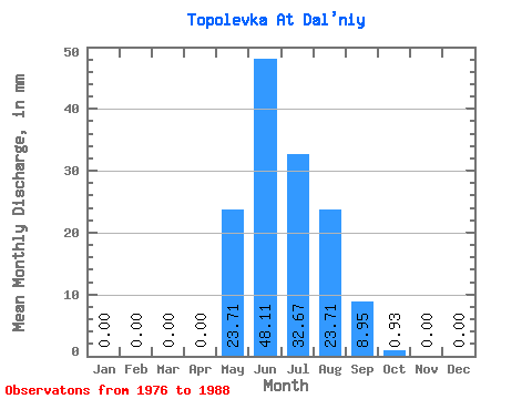
| Statistic | Jan | Feb | Mar | Apr | May | Jun | Jul | Aug | Sep | Oct | Nov | Dec | Annual |
|---|---|---|---|---|---|---|---|---|---|---|---|---|---|
| Mean | 0.00 | 0.00 | 0.00 | 0.00 | 23.71 | 48.10 | 32.66 | 23.70 | 8.95 | 0.93 | 0.00 | 0.00 | 139.84 |
| Standard Deviation | 0.00 | 0.00 | 0.00 | 0.00 | 11.63 | 24.88 | 25.03 | 15.41 | 7.52 | 0.83 | 0.00 | 0.00 | 57.31 |
| Min | 0.00 | 0.00 | 0.00 | 0.00 | 4.94 | 14.89 | 1.23 | 3.42 | 2.57 | 0.32 | 0.00 | 0.00 | 90.82 |
| Max | 0.00 | 0.00 | 0.00 | 0.00 | 40.08 | 86.95 | 88.70 | 50.14 | 26.10 | 3.04 | 0.00 | 0.00 | 202.85 |
| Coefficient of Variation | 0.49 | 0.52 | 0.77 | 0.65 | 0.84 | 0.89 | 0.41 |
 Return to R-Arctic Net Home Page