|
|
|||||||||||||||||
| Point ID: 5936 | Downloads | Plots | Site Data | Code: 1581 |
|
|
|||||||||||||||||
| Download | |
|---|---|
| Site Descriptor Information | Site Time Series Data |
| Link to all available data | |
| View: | Time Series | All |
| Units: | mm |
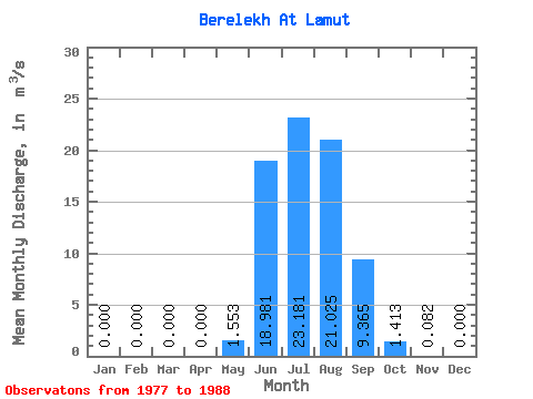
| Statistic | Jan | Feb | Mar | Apr | May | Jun | Jul | Aug | Sep | Oct | Nov | Dec | Annual |
|---|---|---|---|---|---|---|---|---|---|---|---|---|---|
| Mean | 0.00 | 0.00 | 0.00 | 0.00 | 1.55 | 18.98 | 23.18 | 21.02 | 9.37 | 1.41 | 0.08 | 0.00 | 7.00 |
| Standard Deviation | 0.00 | 0.00 | 0.00 | 0.00 | 1.37 | 10.14 | 10.83 | 9.69 | 3.63 | 0.44 | 0.15 | 0.00 | 1.56 |
| Min | 0.00 | 0.00 | 0.00 | 0.00 | 0.00 | 3.82 | 8.39 | 8.78 | 4.66 | 0.62 | 0.00 | 0.00 | 5.21 |
| Max | 0.00 | 0.00 | 0.00 | 0.00 | 4.06 | 41.60 | 49.90 | 40.20 | 16.90 | 2.00 | 0.39 | 0.00 | 7.96 |
| Coefficient of Variation | 0.88 | 0.53 | 0.47 | 0.46 | 0.39 | 0.31 | 1.87 | 0.22 |
 Return to R-Arctic Net Home Page