|
|
|||||||||||||||||
| Point ID: 5936 | Downloads | Plots | Site Data | Code: 1581 |
|
|
|||||||||||||||||
| Download | |
|---|---|
| Site Descriptor Information | Site Time Series Data |
| Link to all available data | |
| View: | Time Series | All |
| Units: | m3/s |
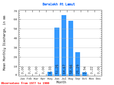
| Statistic | Jan | Feb | Mar | Apr | May | Jun | Jul | Aug | Sep | Oct | Nov | Dec | Annual |
|---|---|---|---|---|---|---|---|---|---|---|---|---|---|
| Mean | 0.00 | 0.00 | 0.00 | 0.00 | 4.33 | 51.25 | 64.67 | 58.65 | 25.28 | 3.94 | 0.22 | 0.00 | 230.14 |
| Standard Deviation | 0.00 | 0.00 | 0.00 | 0.00 | 3.81 | 27.38 | 30.22 | 27.04 | 9.79 | 1.23 | 0.41 | 0.00 | 51.13 |
| Min | 0.00 | 0.00 | 0.00 | 0.00 | 0.00 | 10.31 | 23.41 | 24.49 | 12.58 | 1.73 | 0.00 | 0.00 | 171.15 |
| Max | 0.00 | 0.00 | 0.00 | 0.00 | 11.33 | 112.32 | 139.20 | 112.14 | 45.63 | 5.58 | 1.05 | 0.00 | 261.55 |
| Coefficient of Variation | 0.88 | 0.53 | 0.47 | 0.46 | 0.39 | 0.31 | 1.87 | 0.22 |
 Return to R-Arctic Net Home Page