|
|
|||||||||||||||||
| Point ID: 5920 | Downloads | Plots | Site Data | Code: 1503 |
|
|
|||||||||||||||||
| Download | |
|---|---|
| Site Descriptor Information | Site Time Series Data |
| Link to all available data | |
| View: | Time Series | All |
| Units: | mm |
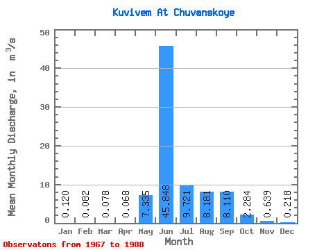
| Statistic | Jan | Feb | Mar | Apr | May | Jun | Jul | Aug | Sep | Oct | Nov | Dec | Annual |
|---|---|---|---|---|---|---|---|---|---|---|---|---|---|
| Mean | 0.12 | 0.08 | 0.08 | 0.07 | 7.33 | 45.85 | 9.72 | 8.18 | 8.11 | 2.28 | 0.64 | 0.22 | 6.94 |
| Standard Deviation | 0.15 | 0.12 | 0.11 | 0.09 | 5.61 | 13.02 | 6.33 | 4.90 | 6.03 | 1.23 | 0.46 | 0.30 | 1.26 |
| Min | 0.00 | 0.00 | 0.00 | 0.00 | 0.21 | 12.90 | 3.18 | 2.34 | 1.54 | 0.61 | 0.09 | 0.01 | 5.12 |
| Max | 0.48 | 0.39 | 0.37 | 0.28 | 16.50 | 66.60 | 23.80 | 20.90 | 23.90 | 6.44 | 1.84 | 1.21 | 9.43 |
| Coefficient of Variation | 1.24 | 1.49 | 1.47 | 1.25 | 0.77 | 0.28 | 0.65 | 0.60 | 0.74 | 0.54 | 0.72 | 1.38 | 0.18 |
 Return to R-Arctic Net Home Page