|
|
|||||||||||||||||
| Point ID: 5920 | Downloads | Plots | Site Data | Code: 1503 |
|
|
|||||||||||||||||
| Download | |
|---|---|
| Site Descriptor Information | Site Time Series Data |
| Link to all available data | |
| View: | Time Series | All |
| Units: | m3/s |
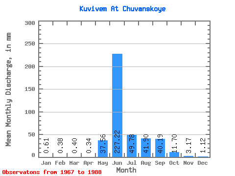
| Statistic | Jan | Feb | Mar | Apr | May | Jun | Jul | Aug | Sep | Oct | Nov | Dec | Annual |
|---|---|---|---|---|---|---|---|---|---|---|---|---|---|
| Mean | 0.61 | 0.38 | 0.40 | 0.34 | 37.56 | 227.22 | 49.78 | 41.89 | 40.19 | 11.69 | 3.17 | 1.11 | 418.74 |
| Standard Deviation | 0.76 | 0.57 | 0.58 | 0.42 | 28.75 | 64.55 | 32.44 | 25.09 | 29.90 | 6.33 | 2.28 | 1.54 | 76.11 |
| Min | 0.00 | 0.00 | 0.00 | 0.00 | 1.07 | 63.93 | 16.28 | 11.98 | 7.63 | 3.12 | 0.43 | 0.04 | 308.77 |
| Max | 2.46 | 1.82 | 1.90 | 1.39 | 84.49 | 330.07 | 121.87 | 107.02 | 118.45 | 32.98 | 9.12 | 6.20 | 569.05 |
| Coefficient of Variation | 1.24 | 1.49 | 1.47 | 1.25 | 0.77 | 0.28 | 0.65 | 0.60 | 0.74 | 0.54 | 0.72 | 1.38 | 0.18 |
 Return to R-Arctic Net Home Page