|
|
|||||||||||||||||
| Point ID: 5916 | Downloads | Plots | Site Data | Code: 1496 |
|
|
|||||||||||||||||
| Download | |
|---|---|
| Site Descriptor Information | Site Time Series Data |
| Link to all available data | |
| View: | Time Series | All |
| Units: | mm |
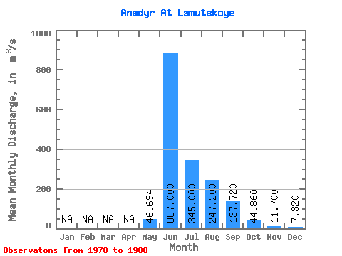
| Statistic | Jan | Feb | Mar | Apr | May | Jun | Jul | Aug | Sep | Oct | Nov | Dec | Annual |
|---|---|---|---|---|---|---|---|---|---|---|---|---|---|
| Mean | 46.69 | 887.00 | 345.00 | 247.20 | 137.72 | 44.86 | 11.70 | 7.32 | |||||
| Standard Deviation | 56.22 | 283.80 | 153.01 | 80.90 | 66.55 | 25.40 | |||||||
| Min | 3.52 | 425.00 | 130.00 | 134.00 | 62.50 | 18.20 | 11.70 | 7.32 | |||||
| Max | 170.00 | 1380.00 | 653.00 | 378.00 | 292.00 | 111.00 | 11.70 | 7.32 | |||||
| Coefficient of Variation | 1.20 | 0.32 | 0.44 | 0.33 | 0.48 | 0.57 |
 Return to R-Arctic Net Home Page