|
|
|||||||||||||||||
| Point ID: 5916 | Downloads | Plots | Site Data | Code: 1496 |
|
|
|||||||||||||||||
| Download | |
|---|---|
| Site Descriptor Information | Site Time Series Data |
| Link to all available data | |
| View: | Time Series | All |
| Units: | m3/s |
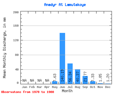
| Statistic | Jan | Feb | Mar | Apr | May | Jun | Jul | Aug | Sep | Oct | Nov | Dec | Annual |
|---|---|---|---|---|---|---|---|---|---|---|---|---|---|
| Mean | 7.62 | 140.19 | 56.34 | 40.37 | 21.77 | 7.33 | 1.85 | 1.20 | |||||
| Standard Deviation | 9.18 | 44.85 | 24.98 | 13.21 | 10.52 | 4.15 | |||||||
| Min | 0.57 | 67.17 | 21.23 | 21.88 | 9.88 | 2.97 | 1.85 | 1.20 | |||||
| Max | 27.76 | 218.11 | 106.63 | 61.73 | 46.15 | 18.12 | 1.85 | 1.20 | |||||
| Coefficient of Variation | 1.20 | 0.32 | 0.44 | 0.33 | 0.48 | 0.57 |
 Return to R-Arctic Net Home Page