|
|
|||||||||||||||||
| Point ID: 5908 | Downloads | Plots | Site Data | Code: 1396 |
|
|
|||||||||||||||||
| Download | |
|---|---|
| Site Descriptor Information | Site Time Series Data |
| Link to all available data | |
| View: | Time Series | All |
| Units: | mm |
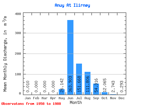
| Statistic | Jan | Feb | Mar | Apr | May | Jun | Jul | Aug | Sep | Oct | Nov | Dec | Annual |
|---|---|---|---|---|---|---|---|---|---|---|---|---|---|
| Mean | 0.01 | 0.00 | 0.00 | 0.00 | 26.14 | 363.90 | 151.67 | 111.81 | 54.32 | 12.06 | 2.74 | 0.29 | 55.95 |
| Standard Deviation | 0.02 | 0.00 | 0.00 | 0.00 | 57.80 | 125.20 | 65.26 | 47.74 | 27.99 | 8.86 | 3.54 | 0.28 | 18.31 |
| Min | 0.00 | 0.00 | 0.00 | 0.00 | 0.02 | 121.00 | 65.00 | 52.30 | 16.50 | 4.20 | 0.29 | 0.00 | 35.05 |
| Max | 0.05 | 0.00 | 0.00 | 0.00 | 301.00 | 701.00 | 355.00 | 214.00 | 137.00 | 44.50 | 18.10 | 1.18 | 69.13 |
| Coefficient of Variation | 1.89 | 2.21 | 0.34 | 0.43 | 0.43 | 0.52 | 0.73 | 1.29 | 0.94 | 0.33 |
 Return to R-Arctic Net Home Page