|
|
|||||||||||||||||
| Point ID: 5908 | Downloads | Plots | Site Data | Code: 1396 |
|
|
|||||||||||||||||
| Download | |
|---|---|
| Site Descriptor Information | Site Time Series Data |
| Link to all available data | |
| View: | Time Series | All |
| Units: | m3/s |
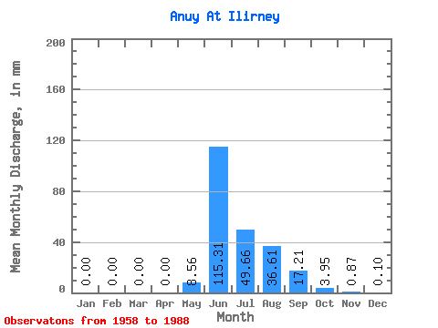
| Statistic | Jan | Feb | Mar | Apr | May | Jun | Jul | Aug | Sep | Oct | Nov | Dec | Annual |
|---|---|---|---|---|---|---|---|---|---|---|---|---|---|
| Mean | 0.00 | 0.00 | 0.00 | 0.00 | 8.56 | 115.31 | 49.65 | 36.60 | 17.21 | 3.95 | 0.87 | 0.10 | 215.88 |
| Standard Deviation | 0.01 | 0.00 | 0.00 | 0.00 | 18.92 | 39.67 | 21.36 | 15.63 | 8.87 | 2.90 | 1.12 | 0.09 | 70.63 |
| Min | 0.00 | 0.00 | 0.00 | 0.00 | 0.01 | 38.34 | 21.28 | 17.12 | 5.23 | 1.38 | 0.09 | 0.00 | 135.24 |
| Max | 0.02 | 0.00 | 0.00 | 0.00 | 98.54 | 222.13 | 116.22 | 70.06 | 43.41 | 14.57 | 5.74 | 0.39 | 266.72 |
| Coefficient of Variation | 1.89 | 2.21 | 0.34 | 0.43 | 0.43 | 0.52 | 0.73 | 1.29 | 0.94 | 0.33 |
 Return to R-Arctic Net Home Page