|
|
|||||||||||||||||
| Point ID: 5901 | Downloads | Plots | Site Data | Code: 1360 |
|
|
|||||||||||||||||
| Download | |
|---|---|
| Site Descriptor Information | Site Time Series Data |
| Link to all available data | |
| View: | Time Series | All |
| Units: | mm |
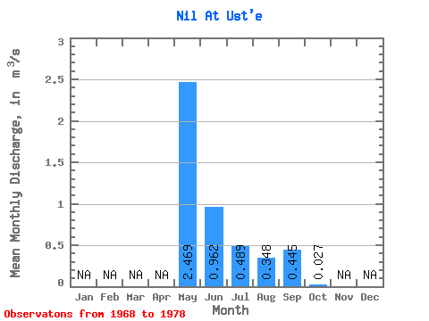
| Statistic | Jan | Feb | Mar | Apr | May | Jun | Jul | Aug | Sep | Oct | Nov | Dec | Annual |
|---|---|---|---|---|---|---|---|---|---|---|---|---|---|
| Mean | 2.47 | 0.96 | 0.49 | 0.35 | 0.45 | 0.03 | |||||||
| Standard Deviation | 1.10 | 0.86 | 0.69 | 0.25 | 0.56 | 0.03 | |||||||
| Min | 1.12 | 0.06 | 0.01 | 0.03 | 0.01 | 0.01 | |||||||
| Max | 4.85 | 3.27 | 2.27 | 0.65 | 1.82 | 0.10 | |||||||
| Coefficient of Variation | 0.45 | 0.89 | 1.42 | 0.71 | 1.26 | 1.16 |
 Return to R-Arctic Net Home Page