|
|
|||||||||||||||||
| Point ID: 5901 | Downloads | Plots | Site Data | Code: 1360 |
|
|
|||||||||||||||||
| Download | |
|---|---|
| Site Descriptor Information | Site Time Series Data |
| Link to all available data | |
| View: | Time Series | All |
| Units: | m3/s |
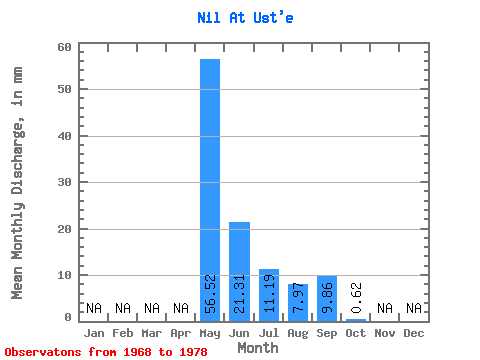
| Statistic | Jan | Feb | Mar | Apr | May | Jun | Jul | Aug | Sep | Oct | Nov | Dec | Annual |
|---|---|---|---|---|---|---|---|---|---|---|---|---|---|
| Mean | 56.52 | 21.32 | 11.20 | 7.98 | 9.85 | 0.63 | |||||||
| Standard Deviation | 25.20 | 18.99 | 15.90 | 5.65 | 12.38 | 0.72 | |||||||
| Min | 25.64 | 1.26 | 0.14 | 0.76 | 0.18 | 0.16 | |||||||
| Max | 111.01 | 72.44 | 51.96 | 14.88 | 40.32 | 2.29 | |||||||
| Coefficient of Variation | 0.45 | 0.89 | 1.42 | 0.71 | 1.26 | 1.16 |
 Return to R-Arctic Net Home Page