|
|
|||||||||||||||||
| Point ID: 5895 | Downloads | Plots | Site Data | Code: 1310 |
|
|
|||||||||||||||||
| Download | |
|---|---|
| Site Descriptor Information | Site Time Series Data |
| Link to all available data | |
| View: | Time Series | All |
| Units: | mm |
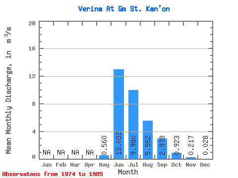
| Statistic | Jan | Feb | Mar | Apr | May | Jun | Jul | Aug | Sep | Oct | Nov | Dec | Annual |
|---|---|---|---|---|---|---|---|---|---|---|---|---|---|
| Mean | 0.56 | 13.03 | 9.98 | 5.55 | 2.98 | 0.92 | 0.22 | 0.03 | |||||
| Standard Deviation | 0.92 | 4.25 | 4.96 | 1.64 | 0.85 | 0.18 | 0.11 | 0.04 | |||||
| Min | 0.05 | 8.69 | 5.55 | 3.22 | 1.72 | 0.80 | 0.12 | 0.00 | |||||
| Max | 1.94 | 19.20 | 17.80 | 7.19 | 3.58 | 1.19 | 0.33 | 0.08 | |||||
| Coefficient of Variation | 1.65 | 0.33 | 0.50 | 0.30 | 0.29 | 0.20 | 0.49 | 1.64 |
 Return to R-Arctic Net Home Page