|
|
|||||||||||||||||
| Point ID: 5895 | Downloads | Plots | Site Data | Code: 1310 |
|
|
|||||||||||||||||
| Download | |
|---|---|
| Site Descriptor Information | Site Time Series Data |
| Link to all available data | |
| View: | Time Series | All |
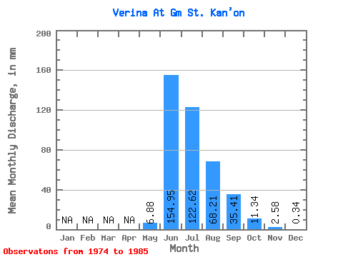
| Units: | m3/s |
| Statistic | Jan | Feb | Mar | Apr | May | Jun | Jul | Aug | Sep | Oct | Nov | Dec | Annual |
|---|---|---|---|---|---|---|---|---|---|---|---|---|---|
| Mean | 6.87 | 154.95 | 122.60 | 68.20 | 35.40 | 11.33 | 2.58 | 0.34 | |||||
| Standard Deviation | 11.31 | 50.58 | 60.90 | 20.16 | 10.11 | 2.21 | 1.26 | 0.56 | |||||
| Min | 0.59 | 103.32 | 68.18 | 39.56 | 20.45 | 9.83 | 1.43 | 0.01 | |||||
| Max | 23.83 | 228.29 | 218.66 | 88.33 | 42.57 | 14.62 | 3.92 | 0.98 | |||||
| Coefficient of Variation | 1.65 | 0.33 | 0.50 | 0.30 | 0.29 | 0.20 | 0.49 | 1.64 |
 Return to R-Arctic Net Home Page