|
|
|||||||||||||||||
| Point ID: 5882 | Downloads | Plots | Site Data | Code: 1218 |
|
|
|||||||||||||||||
| Download | |
|---|---|
| Site Descriptor Information | Site Time Series Data |
| Link to all available data | |
| View: | Time Series | All |
| Units: | mm |
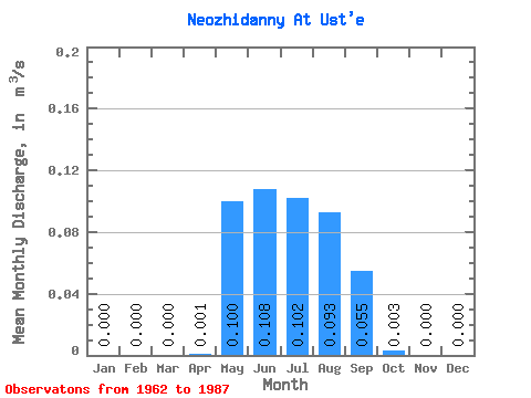
| Statistic | Jan | Feb | Mar | Apr | May | Jun | Jul | Aug | Sep | Oct | Nov | Dec | Annual |
|---|---|---|---|---|---|---|---|---|---|---|---|---|---|
| Mean | 0.00 | 0.00 | 0.00 | 0.00 | 0.10 | 0.11 | 0.10 | 0.09 | 0.06 | 0.00 | 0.00 | 0.00 | 0.06 |
| Standard Deviation | 0.00 | 0.00 | 0.00 | 0.00 | 0.05 | 0.08 | 0.07 | 0.05 | 0.04 | 0.00 | 0.00 | 0.00 | 0.01 |
| Min | 0.00 | 0.00 | 0.00 | 0.00 | 0.02 | 0.02 | 0.02 | 0.02 | 0.02 | 0.00 | 0.00 | 0.00 | 0.05 |
| Max | 0.00 | 0.00 | 0.00 | 0.01 | 0.22 | 0.39 | 0.29 | 0.19 | 0.14 | 0.01 | 0.00 | 0.00 | 0.06 |
| Coefficient of Variation | 2.64 | 0.51 | 0.77 | 0.66 | 0.52 | 0.70 | 0.89 | 0.10 |
 Return to R-Arctic Net Home Page