|
|
|||||||||||||||||
| Point ID: 5882 | Downloads | Plots | Site Data | Code: 1218 |
|
|
|||||||||||||||||
| Download | |
|---|---|
| Site Descriptor Information | Site Time Series Data |
| Link to all available data | |
| View: | Time Series | All |
| Units: | m3/s |
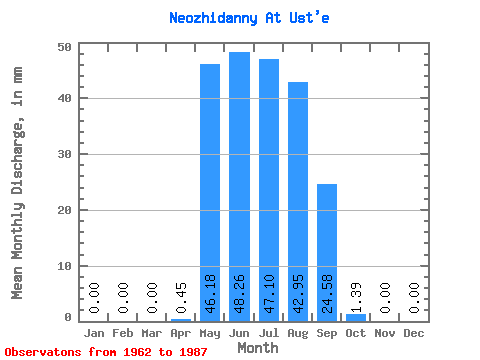
| Statistic | Jan | Feb | Mar | Apr | May | Jun | Jul | Aug | Sep | Oct | Nov | Dec | Annual |
|---|---|---|---|---|---|---|---|---|---|---|---|---|---|
| Mean | 0.00 | 0.00 | 0.00 | 0.30 | 46.13 | 48.46 | 46.91 | 43.07 | 24.54 | 1.53 | 0.00 | 0.00 | 316.51 |
| Standard Deviation | 0.00 | 0.00 | 0.00 | 0.80 | 23.55 | 37.09 | 30.89 | 22.31 | 17.16 | 1.35 | 0.00 | 0.00 | 32.06 |
| Min | 0.00 | 0.00 | 0.00 | 0.00 | 9.23 | 7.15 | 8.31 | 10.62 | 7.15 | 0.46 | 0.00 | 0.00 | 293.83 |
| Max | 0.00 | 0.00 | 0.00 | 2.68 | 101.58 | 174.29 | 133.90 | 87.73 | 62.57 | 5.54 | 0.00 | 0.00 | 339.18 |
| Coefficient of Variation | 2.64 | 0.51 | 0.77 | 0.66 | 0.52 | 0.70 | 0.89 | 0.10 |
 Return to R-Arctic Net Home Page