|
|
|||||||||||||||||
| Point ID: 5874 | Downloads | Plots | Site Data | Code: 1151 |
|
|
|||||||||||||||||
| Download | |
|---|---|
| Site Descriptor Information | Site Time Series Data |
| Link to all available data | |
| View: | Time Series | All |
| Units: | mm |
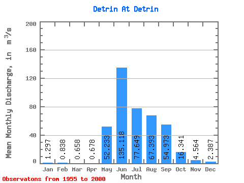
| Statistic | Jan | Feb | Mar | Apr | May | Jun | Jul | Aug | Sep | Oct | Nov | Dec | Annual |
|---|---|---|---|---|---|---|---|---|---|---|---|---|---|
| Mean | 1.30 | 0.84 | 0.66 | 0.68 | 52.23 | 135.12 | 77.65 | 67.39 | 54.97 | 16.34 | 4.56 | 2.39 | 34.27 |
| Standard Deviation | 0.42 | 0.28 | 0.27 | 0.28 | 37.15 | 78.26 | 41.80 | 37.48 | 34.31 | 8.84 | 1.11 | 0.75 | 8.95 |
| Min | 0.64 | 0.23 | 0.00 | 0.00 | 2.65 | 33.60 | 29.00 | 21.50 | 17.90 | 7.24 | 2.99 | 1.42 | 20.28 |
| Max | 2.73 | 1.61 | 1.48 | 1.41 | 197.00 | 458.00 | 217.00 | 193.00 | 160.00 | 47.30 | 7.01 | 4.50 | 54.05 |
| Coefficient of Variation | 0.33 | 0.33 | 0.41 | 0.41 | 0.71 | 0.58 | 0.54 | 0.56 | 0.62 | 0.54 | 0.24 | 0.31 | 0.26 |
 Return to R-Arctic Net Home Page