|
|
|||||||||||||||||
| Point ID: 5874 | Downloads | Plots | Site Data | Code: 1151 |
|
|
|||||||||||||||||
| Download | |
|---|---|
| Site Descriptor Information | Site Time Series Data |
| Link to all available data | |
| View: | Time Series | All |
| Units: | m3/s |
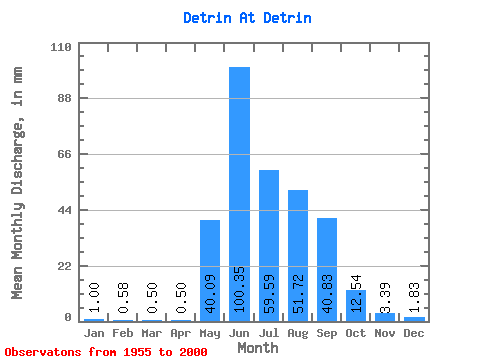
| Statistic | Jan | Feb | Mar | Apr | May | Jun | Jul | Aug | Sep | Oct | Nov | Dec | Annual |
|---|---|---|---|---|---|---|---|---|---|---|---|---|---|
| Mean | 0.99 | 0.59 | 0.51 | 0.50 | 40.08 | 100.35 | 59.58 | 51.71 | 40.83 | 12.54 | 3.39 | 1.83 | 309.93 |
| Standard Deviation | 0.32 | 0.19 | 0.21 | 0.21 | 28.51 | 58.12 | 32.08 | 28.76 | 25.48 | 6.79 | 0.82 | 0.57 | 80.95 |
| Min | 0.49 | 0.16 | 0.00 | 0.00 | 2.03 | 24.95 | 22.25 | 16.50 | 13.29 | 5.56 | 2.22 | 1.09 | 183.38 |
| Max | 2.10 | 1.13 | 1.14 | 1.05 | 151.16 | 340.15 | 166.51 | 148.10 | 118.83 | 36.30 | 5.21 | 3.45 | 488.74 |
| Coefficient of Variation | 0.33 | 0.33 | 0.41 | 0.41 | 0.71 | 0.58 | 0.54 | 0.56 | 0.62 | 0.54 | 0.24 | 0.31 | 0.26 |
 Return to R-Arctic Net Home Page