|
|
|||||||||||||||||
| Point ID: 5872 | Downloads | Plots | Site Data | Code: 1146 |
|
|
|||||||||||||||||
| Download | |
|---|---|
| Site Descriptor Information | Site Time Series Data |
| Link to all available data | |
| View: | Time Series | All |
| Units: | mm |
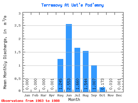
| Statistic | Jan | Feb | Mar | Apr | May | Jun | Jul | Aug | Sep | Oct | Nov | Dec | Annual |
|---|---|---|---|---|---|---|---|---|---|---|---|---|---|
| Mean | 0.00 | 0.00 | 0.00 | 0.00 | 1.25 | 2.55 | 1.66 | 1.54 | 1.01 | 0.17 | 0.01 | 0.00 | 0.58 |
| Standard Deviation | 0.00 | 0.00 | 0.00 | 0.00 | 0.80 | 1.38 | 0.83 | 0.79 | 0.70 | 0.14 | 0.01 | 0.00 | 0.41 |
| Min | 0.00 | 0.00 | 0.00 | 0.00 | 0.24 | 0.79 | 0.32 | 0.26 | 0.10 | 0.02 | 0.00 | 0.00 | 0.16 |
| Max | 0.00 | 0.00 | 0.00 | 0.00 | 3.86 | 6.50 | 3.66 | 3.33 | 2.76 | 0.72 | 0.05 | 0.01 | 0.98 |
| Coefficient of Variation | 1.23 | 0.64 | 0.54 | 0.50 | 0.51 | 0.69 | 0.81 | 1.17 | 2.00 | 0.71 |
 Return to R-Arctic Net Home Page