|
|
|||||||||||||||||
| Point ID: 5872 | Downloads | Plots | Site Data | Code: 1146 |
|
|
|||||||||||||||||
| Download | |
|---|---|
| Site Descriptor Information | Site Time Series Data |
| Link to all available data | |
| View: | Time Series | All |
| Units: | m3/s |
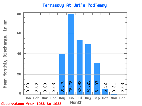
| Statistic | Jan | Feb | Mar | Apr | May | Jun | Jul | Aug | Sep | Oct | Nov | Dec | Annual |
|---|---|---|---|---|---|---|---|---|---|---|---|---|---|
| Mean | 0.00 | 0.00 | 0.00 | 0.02 | 39.70 | 78.78 | 52.94 | 49.21 | 31.07 | 5.52 | 0.29 | 0.04 | 218.61 |
| Standard Deviation | 0.00 | 0.00 | 0.00 | 0.03 | 25.42 | 42.63 | 26.60 | 25.20 | 21.50 | 4.47 | 0.34 | 0.08 | 155.15 |
| Min | 0.00 | 0.00 | 0.00 | 0.00 | 7.65 | 24.38 | 10.20 | 8.29 | 2.93 | 0.70 | 0.00 | 0.00 | 59.08 |
| Max | 0.00 | 0.00 | 0.00 | 0.06 | 123.06 | 200.57 | 116.68 | 106.16 | 85.17 | 22.95 | 1.42 | 0.16 | 368.98 |
| Coefficient of Variation | 1.23 | 0.64 | 0.54 | 0.50 | 0.51 | 0.69 | 0.81 | 1.17 | 2.00 | 0.71 |
 Return to R-Arctic Net Home Page