|
|
|||||||||||||||||
| Point ID: 5871 | Downloads | Plots | Site Data | Code: 1144 |
|
|
|||||||||||||||||
| Download | |
|---|---|
| Site Descriptor Information | Site Time Series Data |
| Link to all available data | |
| View: | Time Series | All |
| Units: | mm |
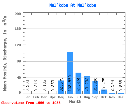
| Statistic | Jan | Feb | Mar | Apr | May | Jun | Jul | Aug | Sep | Oct | Nov | Dec | Annual |
|---|---|---|---|---|---|---|---|---|---|---|---|---|---|
| Mean | 0.30 | 0.22 | 0.14 | 0.25 | 32.68 | 102.99 | 51.82 | 43.78 | 31.80 | 10.47 | 2.54 | 0.84 | 21.49 |
| Standard Deviation | 0.42 | 0.31 | 0.28 | 0.27 | 22.18 | 41.98 | 21.75 | 19.64 | 18.15 | 4.78 | 1.35 | 0.69 | 3.00 |
| Min | 0.01 | 0.00 | 0.00 | 0.00 | 4.76 | 33.90 | 23.90 | 17.70 | 11.50 | 5.09 | 0.59 | 0.10 | 17.95 |
| Max | 1.46 | 0.98 | 0.70 | 1.06 | 99.50 | 196.00 | 121.00 | 96.60 | 79.40 | 26.50 | 7.06 | 2.63 | 25.13 |
| Coefficient of Variation | 1.38 | 1.45 | 2.06 | 1.05 | 0.68 | 0.41 | 0.42 | 0.45 | 0.57 | 0.46 | 0.53 | 0.82 | 0.14 |
 Return to R-Arctic Net Home Page