|
|
|||||||||||||||||
| Point ID: 5871 | Downloads | Plots | Site Data | Code: 1144 |
|
|
|||||||||||||||||
| Download | |
|---|---|
| Site Descriptor Information | Site Time Series Data |
| Link to all available data | |
| View: | Time Series | All |
| Units: | m3/s |
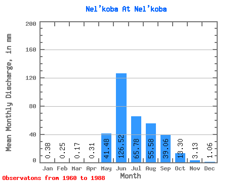
| Statistic | Jan | Feb | Mar | Apr | May | Jun | Jul | Aug | Sep | Oct | Nov | Dec | Annual |
|---|---|---|---|---|---|---|---|---|---|---|---|---|---|
| Mean | 0.39 | 0.25 | 0.17 | 0.31 | 41.48 | 126.52 | 65.78 | 55.57 | 39.06 | 13.29 | 3.12 | 1.06 | 321.48 |
| Standard Deviation | 0.53 | 0.36 | 0.35 | 0.33 | 28.14 | 51.58 | 27.61 | 24.93 | 22.30 | 6.07 | 1.66 | 0.87 | 44.90 |
| Min | 0.01 | 0.00 | 0.00 | 0.00 | 6.04 | 41.64 | 30.33 | 22.46 | 14.13 | 6.46 | 0.72 | 0.12 | 268.52 |
| Max | 1.85 | 1.13 | 0.89 | 1.30 | 126.28 | 240.77 | 153.57 | 122.60 | 97.54 | 33.63 | 8.67 | 3.34 | 375.93 |
| Coefficient of Variation | 1.38 | 1.45 | 2.06 | 1.05 | 0.68 | 0.41 | 0.42 | 0.45 | 0.57 | 0.46 | 0.53 | 0.82 | 0.14 |
 Return to R-Arctic Net Home Page