|
|
|||||||||||||||||
| Point ID: 5868 | Downloads | Plots | Site Data | Code: 1124 |
|
|
|||||||||||||||||
| Download | |
|---|---|
| Site Descriptor Information | Site Time Series Data |
| Link to all available data | |
| View: | Time Series | All |
| Units: | mm |
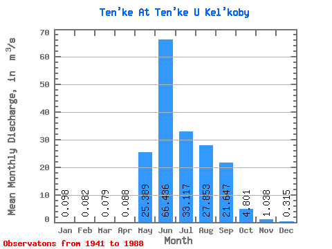
| Statistic | Jan | Feb | Mar | Apr | May | Jun | Jul | Aug | Sep | Oct | Nov | Dec | Annual |
|---|---|---|---|---|---|---|---|---|---|---|---|---|---|
| Mean | 0.10 | 0.08 | 0.08 | 0.09 | 25.39 | 66.44 | 33.12 | 27.85 | 21.65 | 4.80 | 1.04 | 0.32 | 15.97 |
| Standard Deviation | 0.16 | 0.15 | 0.15 | 0.12 | 18.47 | 39.61 | 15.93 | 13.97 | 13.99 | 3.03 | 0.62 | 0.26 | 2.23 |
| Min | 0.00 | 0.00 | 0.00 | 0.00 | 0.54 | 16.60 | 11.80 | 9.81 | 4.44 | 0.86 | 0.05 | 0.00 | 13.14 |
| Max | 0.76 | 0.42 | 0.31 | 0.40 | 84.70 | 199.00 | 89.60 | 68.20 | 55.90 | 19.90 | 2.38 | 1.25 | 17.92 |
| Coefficient of Variation | 1.63 | 1.88 | 1.94 | 1.42 | 0.73 | 0.60 | 0.48 | 0.50 | 0.65 | 0.63 | 0.59 | 0.83 | 0.14 |
 Return to R-Arctic Net Home Page