|
|
|||||||||||||||||
| Point ID: 5868 | Downloads | Plots | Site Data | Code: 1124 |
|
|
|||||||||||||||||
| Download | |
|---|---|
| Site Descriptor Information | Site Time Series Data |
| Link to all available data | |
| View: | Time Series | All |
| Units: | m3/s |
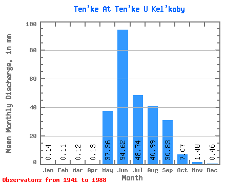
| Statistic | Jan | Feb | Mar | Apr | May | Jun | Jul | Aug | Sep | Oct | Nov | Dec | Annual |
|---|---|---|---|---|---|---|---|---|---|---|---|---|---|
| Mean | 0.14 | 0.11 | 0.12 | 0.12 | 37.36 | 94.62 | 48.73 | 40.98 | 30.83 | 7.06 | 1.48 | 0.46 | 276.88 |
| Standard Deviation | 0.24 | 0.21 | 0.23 | 0.18 | 27.18 | 56.42 | 23.44 | 20.55 | 19.92 | 4.46 | 0.88 | 0.39 | 38.69 |
| Min | 0.00 | 0.00 | 0.00 | 0.00 | 0.80 | 23.64 | 17.36 | 14.44 | 6.32 | 1.27 | 0.07 | 0.00 | 227.87 |
| Max | 1.12 | 0.56 | 0.46 | 0.57 | 124.63 | 283.41 | 131.84 | 100.35 | 79.61 | 29.28 | 3.39 | 1.84 | 310.72 |
| Coefficient of Variation | 1.63 | 1.88 | 1.94 | 1.42 | 0.73 | 0.60 | 0.48 | 0.50 | 0.65 | 0.63 | 0.59 | 0.83 | 0.14 |
 Return to R-Arctic Net Home Page