|
|
|||||||||||||||||
| Point ID: 5864 | Downloads | Plots | Site Data | Code: 1081 |
|
|
|||||||||||||||||
| Download | |
|---|---|
| Site Descriptor Information | Site Time Series Data |
| Link to all available data | |
| View: | Time Series | All |
| Units: | mm |
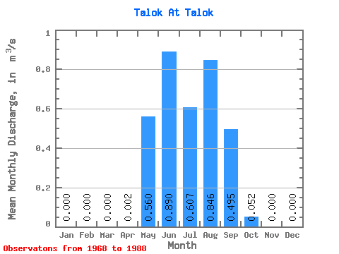
| Statistic | Jan | Feb | Mar | Apr | May | Jun | Jul | Aug | Sep | Oct | Nov | Dec | Annual |
|---|---|---|---|---|---|---|---|---|---|---|---|---|---|
| Mean | 0.00 | 0.00 | 0.00 | 0.00 | 0.56 | 0.89 | 0.61 | 0.85 | 0.49 | 0.05 | 0.00 | 0.00 | 0.38 |
| Standard Deviation | 0.00 | 0.00 | 0.00 | 0.00 | 0.34 | 0.69 | 0.31 | 0.57 | 0.34 | 0.03 | 0.00 | 0.00 | 0.04 |
| Min | 0.00 | 0.00 | 0.00 | 0.00 | 0.15 | 0.12 | 0.17 | 0.18 | 0.13 | 0.01 | 0.00 | 0.00 | 0.33 |
| Max | 0.00 | 0.00 | 0.00 | 0.01 | 1.30 | 2.60 | 1.48 | 2.10 | 1.36 | 0.13 | 0.00 | 0.00 | 0.40 |
| Coefficient of Variation | 1.94 | 0.61 | 0.77 | 0.52 | 0.68 | 0.69 | 0.55 | 0.12 |
 Return to R-Arctic Net Home Page