|
|
|||||||||||||||||
| Point ID: 5864 | Downloads | Plots | Site Data | Code: 1081 |
|
|
|||||||||||||||||
| Download | |
|---|---|
| Site Descriptor Information | Site Time Series Data |
| Link to all available data | |
| View: | Time Series | All |
| Units: | m3/s |
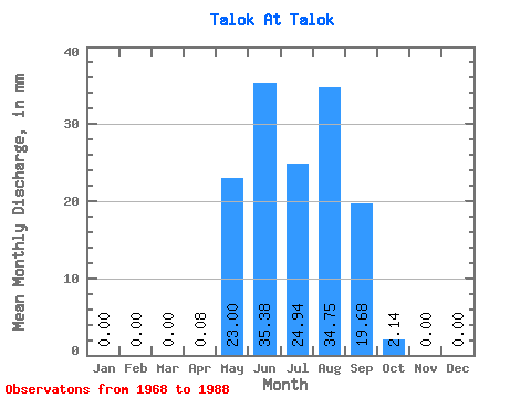
| Statistic | Jan | Feb | Mar | Apr | May | Jun | Jul | Aug | Sep | Oct | Nov | Dec | Annual |
|---|---|---|---|---|---|---|---|---|---|---|---|---|---|
| Mean | 0.00 | 0.00 | 0.00 | 0.07 | 22.98 | 35.36 | 24.94 | 34.74 | 19.69 | 2.12 | 0.00 | 0.00 | 182.85 |
| Standard Deviation | 0.00 | 0.00 | 0.00 | 0.14 | 14.10 | 27.26 | 12.90 | 23.47 | 13.60 | 1.17 | 0.00 | 0.00 | 21.49 |
| Min | 0.00 | 0.00 | 0.00 | 0.00 | 6.16 | 4.77 | 6.98 | 7.39 | 5.17 | 0.33 | 0.00 | 0.00 | 158.04 |
| Max | 0.00 | 0.00 | 0.00 | 0.32 | 53.40 | 103.36 | 60.79 | 86.25 | 54.07 | 5.34 | 0.00 | 0.00 | 195.68 |
| Coefficient of Variation | 1.94 | 0.61 | 0.77 | 0.52 | 0.68 | 0.69 | 0.55 | 0.12 |
 Return to R-Arctic Net Home Page