|
|
|||||||||||||||||
| Point ID: 5863 | Downloads | Plots | Site Data | Code: 1080 |
|
|
|||||||||||||||||
| Download | |
|---|---|
| Site Descriptor Information | Site Time Series Data |
| Link to all available data | |
| View: | Time Series | All |
| Units: | mm |
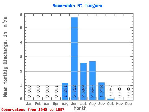
| Statistic | Jan | Feb | Mar | Apr | May | Jun | Jul | Aug | Sep | Oct | Nov | Dec | Annual |
|---|---|---|---|---|---|---|---|---|---|---|---|---|---|
| Mean | 0.00 | 0.00 | 0.00 | 0.00 | 1.20 | 5.71 | 2.57 | 2.68 | 1.22 | 0.09 | 0.00 | 0.00 | 1.12 |
| Standard Deviation | 0.00 | 0.00 | 0.00 | 0.00 | 1.10 | 2.59 | 1.44 | 2.13 | 0.73 | 0.06 | 0.00 | 0.00 | 0.37 |
| Min | 0.00 | 0.00 | 0.00 | 0.00 | 0.03 | 1.64 | 0.59 | 0.63 | 0.22 | 0.02 | 0.00 | 0.00 | 0.49 |
| Max | 0.00 | 0.00 | 0.00 | 0.02 | 5.05 | 13.00 | 7.17 | 14.00 | 4.14 | 0.23 | 0.00 | 0.00 | 2.35 |
| Coefficient of Variation | 4.24 | 0.91 | 0.45 | 0.56 | 0.79 | 0.60 | 0.69 | 0.33 |
 Return to R-Arctic Net Home Page