|
|
|||||||||||||||||
| Point ID: 5863 | Downloads | Plots | Site Data | Code: 1080 |
|
|
|||||||||||||||||
| Download | |
|---|---|
| Site Descriptor Information | Site Time Series Data |
| Link to all available data | |
| View: | Time Series | All |
| Units: | m3/s |
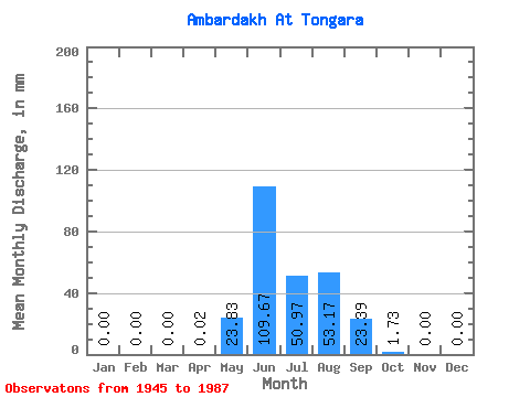
| Statistic | Jan | Feb | Mar | Apr | May | Jun | Jul | Aug | Sep | Oct | Nov | Dec | Annual |
|---|---|---|---|---|---|---|---|---|---|---|---|---|---|
| Mean | 0.00 | 0.00 | 0.00 | 0.01 | 23.82 | 109.68 | 50.96 | 53.17 | 23.39 | 1.72 | 0.00 | 0.00 | 262.38 |
| Standard Deviation | 0.00 | 0.00 | 0.00 | 0.06 | 21.78 | 49.74 | 28.59 | 42.18 | 14.08 | 1.18 | 0.00 | 0.00 | 85.83 |
| Min | 0.00 | 0.00 | 0.00 | 0.00 | 0.50 | 31.49 | 11.70 | 12.50 | 4.22 | 0.44 | 0.00 | 0.00 | 114.34 |
| Max | 0.00 | 0.00 | 0.00 | 0.38 | 100.18 | 249.60 | 142.23 | 277.72 | 79.49 | 4.56 | 0.00 | 0.00 | 548.77 |
| Coefficient of Variation | 4.24 | 0.91 | 0.45 | 0.56 | 0.79 | 0.60 | 0.69 | 0.33 |
 Return to R-Arctic Net Home Page