|
|
|||||||||||||||||
| Point ID: 5861 | Downloads | Plots | Site Data | Code: 1050 |
|
|
|||||||||||||||||
| Download | |
|---|---|
| Site Descriptor Information | Site Time Series Data |
| Link to all available data | |
| View: | Time Series | All |
| Units: | mm |
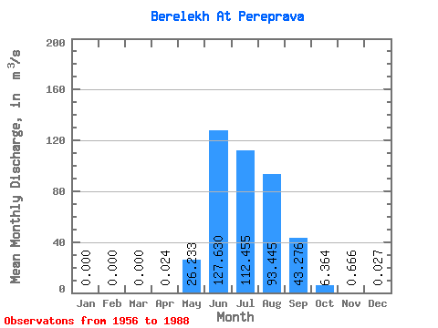
| Statistic | Jan | Feb | Mar | Apr | May | Jun | Jul | Aug | Sep | Oct | Nov | Dec | Annual |
|---|---|---|---|---|---|---|---|---|---|---|---|---|---|
| Mean | 0.00 | 0.00 | 0.00 | 0.02 | 26.23 | 127.63 | 112.45 | 93.44 | 43.28 | 6.36 | 0.67 | 0.03 | 35.22 |
| Standard Deviation | 0.00 | 0.00 | 0.00 | 0.05 | 25.03 | 54.97 | 47.13 | 41.10 | 18.71 | 2.66 | 0.82 | 0.03 | 8.75 |
| Min | 0.00 | 0.00 | 0.00 | 0.00 | 2.91 | 31.70 | 38.80 | 32.80 | 16.70 | 2.47 | 0.01 | 0.00 | 25.17 |
| Max | 0.00 | 0.00 | 0.00 | 0.10 | 107.00 | 269.00 | 231.00 | 192.00 | 86.40 | 13.60 | 3.80 | 0.08 | 41.06 |
| Coefficient of Variation | 2.00 | 0.95 | 0.43 | 0.42 | 0.44 | 0.43 | 0.42 | 1.23 | 0.94 | 0.25 |
 Return to R-Arctic Net Home Page