|
|
|||||||||||||||||
| Point ID: 5861 | Downloads | Plots | Site Data | Code: 1050 |
|
|
|||||||||||||||||
| Download | |
|---|---|
| Site Descriptor Information | Site Time Series Data |
| Link to all available data | |
| View: | Time Series | All |
| Units: | m3/s |
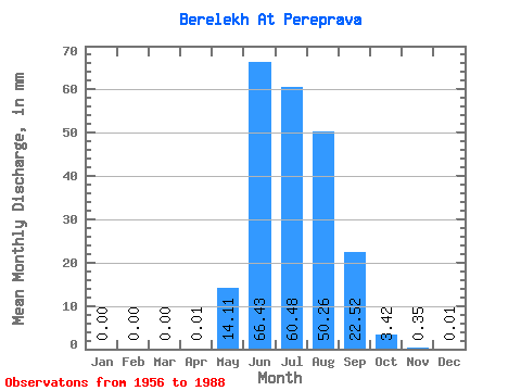
| Statistic | Jan | Feb | Mar | Apr | May | Jun | Jul | Aug | Sep | Oct | Nov | Dec | Annual |
|---|---|---|---|---|---|---|---|---|---|---|---|---|---|
| Mean | 0.00 | 0.00 | 0.00 | 0.01 | 14.11 | 66.43 | 60.47 | 50.25 | 22.52 | 3.42 | 0.35 | 0.01 | 223.22 |
| Standard Deviation | 0.00 | 0.00 | 0.00 | 0.03 | 13.46 | 28.61 | 25.35 | 22.10 | 9.74 | 1.43 | 0.43 | 0.01 | 55.43 |
| Min | 0.00 | 0.00 | 0.00 | 0.00 | 1.56 | 16.50 | 20.86 | 17.64 | 8.69 | 1.33 | 0.01 | 0.00 | 159.50 |
| Max | 0.00 | 0.00 | 0.00 | 0.05 | 57.54 | 140.01 | 124.22 | 103.25 | 44.97 | 7.31 | 1.98 | 0.04 | 260.22 |
| Coefficient of Variation | 2.00 | 0.95 | 0.43 | 0.42 | 0.44 | 0.43 | 0.42 | 1.23 | 0.94 | 0.25 |
 Return to R-Arctic Net Home Page