|
|
|||||||||||||||||
| Point ID: 5860 | Downloads | Plots | Site Data | Code: 1037 |
|
|
|||||||||||||||||
| Download | |
|---|---|
| Site Descriptor Information | Site Time Series Data |
| Link to all available data | |
| View: | Time Series | All |
| Units: | mm |
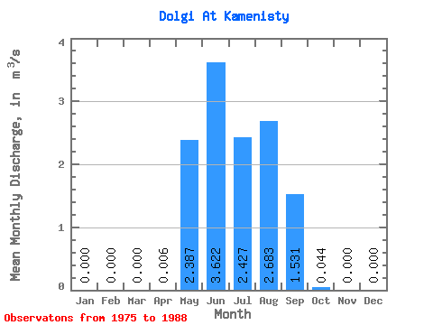
| Statistic | Jan | Feb | Mar | Apr | May | Jun | Jul | Aug | Sep | Oct | Nov | Dec | Annual |
|---|---|---|---|---|---|---|---|---|---|---|---|---|---|
| Mean | 0.00 | 0.00 | 0.00 | 0.01 | 2.39 | 3.62 | 2.43 | 2.68 | 1.53 | 0.04 | 0.00 | 0.00 | 1.28 |
| Standard Deviation | 0.00 | 0.00 | 0.00 | 0.01 | 1.42 | 2.92 | 1.59 | 1.99 | 1.14 | 0.03 | 0.00 | 0.00 | 0.25 |
| Min | 0.00 | 0.00 | 0.00 | 0.00 | 0.43 | 0.38 | 0.38 | 0.32 | 0.11 | 0.00 | 0.00 | 0.00 | 1.05 |
| Max | 0.00 | 0.00 | 0.00 | 0.02 | 4.71 | 9.52 | 5.55 | 6.70 | 4.13 | 0.09 | 0.00 | 0.00 | 1.54 |
| Coefficient of Variation | 2.00 | 0.59 | 0.81 | 0.66 | 0.74 | 0.74 | 0.58 | 0.19 |
 Return to R-Arctic Net Home Page