|
|
|||||||||||||||||
| Point ID: 5860 | Downloads | Plots | Site Data | Code: 1037 |
|
|
|||||||||||||||||
| Download | |
|---|---|
| Site Descriptor Information | Site Time Series Data |
| Link to all available data | |
| View: | Time Series | All |
| Units: | m3/s |
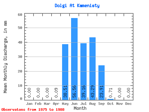
| Statistic | Jan | Feb | Mar | Apr | May | Jun | Jul | Aug | Sep | Oct | Nov | Dec | Annual |
|---|---|---|---|---|---|---|---|---|---|---|---|---|---|
| Mean | 0.00 | 0.00 | 0.00 | 0.09 | 38.51 | 56.56 | 39.16 | 43.28 | 23.91 | 0.71 | 0.00 | 0.00 | 243.58 |
| Standard Deviation | 0.00 | 0.00 | 0.00 | 0.19 | 22.90 | 45.59 | 25.64 | 32.08 | 17.76 | 0.41 | 0.00 | 0.00 | 46.82 |
| Min | 0.00 | 0.00 | 0.00 | 0.00 | 6.94 | 5.93 | 6.13 | 5.16 | 1.72 | 0.07 | 0.00 | 0.00 | 199.83 |
| Max | 0.00 | 0.00 | 0.00 | 0.38 | 75.98 | 148.65 | 89.54 | 108.09 | 64.49 | 1.37 | 0.00 | 0.00 | 292.96 |
| Coefficient of Variation | 2.00 | 0.59 | 0.81 | 0.66 | 0.74 | 0.74 | 0.58 | 0.19 |
 Return to R-Arctic Net Home Page