|
|
|||||||||||||||||
| Point ID: 5856 | Downloads | Plots | Site Data | Code: 1002 |
|
|
|||||||||||||||||
| Download | |
|---|---|
| Site Descriptor Information | Site Time Series Data |
| Link to all available data | |
| View: | Time Series | All |
| Units: | mm |
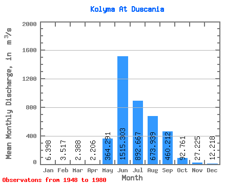
| Statistic | Jan | Feb | Mar | Apr | May | Jun | Jul | Aug | Sep | Oct | Nov | Dec | Annual |
|---|---|---|---|---|---|---|---|---|---|---|---|---|---|
| Mean | 6.40 | 3.52 | 2.39 | 2.21 | 364.29 | 1515.30 | 892.67 | 673.94 | 460.21 | 92.76 | 27.23 | 12.22 | 333.89 |
| Standard Deviation | 4.09 | 2.67 | 1.84 | 1.75 | 351.98 | 809.86 | 383.90 | 268.18 | 255.50 | 33.00 | 9.49 | 5.85 | 83.82 |
| Min | 0.63 | 0.98 | 0.53 | 0.34 | 73.00 | 288.00 | 368.00 | 271.00 | 143.00 | 34.60 | 11.10 | 4.10 | 151.82 |
| Max | 20.70 | 13.00 | 9.07 | 8.03 | 1500.00 | 3830.00 | 2140.00 | 1190.00 | 1390.00 | 164.00 | 52.30 | 32.80 | 490.84 |
| Coefficient of Variation | 0.64 | 0.76 | 0.77 | 0.79 | 0.97 | 0.53 | 0.43 | 0.40 | 0.56 | 0.36 | 0.35 | 0.48 | 0.25 |
 Return to R-Arctic Net Home Page