|
|
|||||||||||||||||
| Point ID: 5856 | Downloads | Plots | Site Data | Code: 1002 |
|
|
|||||||||||||||||
| Download | |
|---|---|
| Site Descriptor Information | Site Time Series Data |
| Link to all available data | |
| View: | Time Series | All |
| Units: | m3/s |
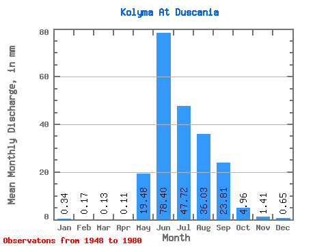
| Statistic | Jan | Feb | Mar | Apr | May | Jun | Jul | Aug | Sep | Oct | Nov | Dec | Annual |
|---|---|---|---|---|---|---|---|---|---|---|---|---|---|
| Mean | 0.34 | 0.17 | 0.13 | 0.11 | 19.47 | 78.40 | 47.72 | 36.02 | 23.81 | 4.96 | 1.41 | 0.65 | 210.33 |
| Standard Deviation | 0.22 | 0.13 | 0.10 | 0.09 | 18.81 | 41.90 | 20.52 | 14.34 | 13.22 | 1.76 | 0.49 | 0.31 | 52.80 |
| Min | 0.03 | 0.05 | 0.03 | 0.02 | 3.90 | 14.90 | 19.67 | 14.49 | 7.40 | 1.85 | 0.57 | 0.22 | 95.64 |
| Max | 1.11 | 0.63 | 0.48 | 0.41 | 80.18 | 198.15 | 114.39 | 63.61 | 71.91 | 8.77 | 2.71 | 1.75 | 309.20 |
| Coefficient of Variation | 0.64 | 0.76 | 0.77 | 0.79 | 0.97 | 0.53 | 0.43 | 0.40 | 0.56 | 0.36 | 0.35 | 0.48 | 0.25 |
 Return to R-Arctic Net Home Page