|
|
|||||||||||||||||
| Point ID: 5844 | Downloads | Plots | Site Data | Code: 10AB003 |
|
|
|||||||||||||||||
| Download | |
|---|---|
| Site Descriptor Information | Site Time Series Data |
| Link to all available data | |
| View: | Time Series | All |
| Units: | mm |
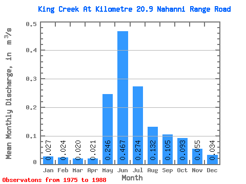
| Statistic | Jan | Feb | Mar | Apr | May | Jun | Jul | Aug | Sep | Oct | Nov | Dec | Annual |
|---|---|---|---|---|---|---|---|---|---|---|---|---|---|
| Mean | 0.03 | 0.02 | 0.02 | 0.02 | 0.25 | 0.47 | 0.27 | 0.13 | 0.10 | 0.09 | 0.06 | 0.03 | 0.12 |
| Standard Deviation | 0.01 | 0.02 | 0.01 | 0.01 | 0.10 | 0.16 | 0.12 | 0.05 | 0.03 | 0.05 | 0.02 | 0.01 | 0.04 |
| Min | 0.00 | 0.00 | 0.00 | 0.01 | 0.07 | 0.26 | 0.10 | 0.08 | 0.06 | 0.04 | 0.02 | 0.01 | 0.08 |
| Max | 0.06 | 0.06 | 0.04 | 0.04 | 0.45 | 0.76 | 0.53 | 0.26 | 0.16 | 0.22 | 0.10 | 0.05 | 0.21 |
| Coefficient of Variation | 0.57 | 0.75 | 0.59 | 0.44 | 0.40 | 0.35 | 0.45 | 0.37 | 0.30 | 0.54 | 0.43 | 0.36 | 0.28 |
 Return to R-Arctic Net Home Page