|
|
|||||||||||||||||
| Point ID: 5844 | Downloads | Plots | Site Data | Code: 10AB003 |
|
|
|||||||||||||||||
| Download | |
|---|---|
| Site Descriptor Information | Site Time Series Data |
| Link to all available data | |
| View: | Time Series | All |
| Units: | m3/s |
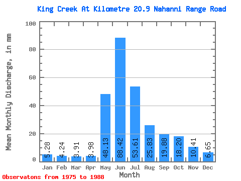
| Statistic | Jan | Feb | Mar | Apr | May | Jun | Jul | Aug | Sep | Oct | Nov | Dec | Annual |
|---|---|---|---|---|---|---|---|---|---|---|---|---|---|
| Mean | 5.22 | 4.24 | 3.88 | 3.92 | 48.12 | 88.47 | 53.63 | 25.88 | 19.88 | 18.26 | 10.32 | 6.72 | 288.98 |
| Standard Deviation | 2.96 | 3.16 | 2.29 | 1.71 | 19.36 | 31.06 | 24.20 | 9.48 | 5.94 | 9.92 | 4.39 | 2.39 | 80.80 |
| Min | 0.59 | 0.00 | 0.39 | 1.89 | 13.50 | 48.85 | 19.56 | 16.04 | 10.98 | 7.83 | 3.79 | 2.35 | 176.36 |
| Max | 12.13 | 10.16 | 8.02 | 8.33 | 88.03 | 143.71 | 104.46 | 51.45 | 30.86 | 43.82 | 18.18 | 10.37 | 478.36 |
| Coefficient of Variation | 0.57 | 0.75 | 0.59 | 0.44 | 0.40 | 0.35 | 0.45 | 0.37 | 0.30 | 0.54 | 0.43 | 0.36 | 0.28 |
 Return to R-Arctic Net Home Page