|
|
|||||||||||||||||
| Point ID: 5840 | Downloads | Plots | Site Data | Code: 10AA002 |
|
|
|||||||||||||||||
| Download | |
|---|---|
| Site Descriptor Information | Site Time Series Data |
| Link to all available data | |
| View: | Time Series | All |
| Units: | mm |
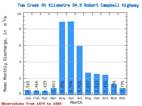
| Statistic | Jan | Feb | Mar | Apr | May | Jun | Jul | Aug | Sep | Oct | Nov | Dec | Annual |
|---|---|---|---|---|---|---|---|---|---|---|---|---|---|
| Mean | 0.56 | 0.47 | 0.44 | 0.80 | 8.86 | 8.91 | 5.92 | 2.66 | 2.51 | 2.42 | 1.30 | 0.80 | 2.98 |
| Standard Deviation | 0.23 | 0.17 | 0.17 | 0.33 | 4.05 | 6.04 | 4.20 | 1.08 | 0.87 | 1.17 | 0.54 | 0.35 | 1.11 |
| Min | 0.20 | 0.17 | 0.15 | 0.15 | 3.11 | 1.95 | 2.06 | 1.55 | 1.29 | 1.21 | 0.58 | 0.33 | 1.50 |
| Max | 1.03 | 0.79 | 0.73 | 1.34 | 21.30 | 28.60 | 16.70 | 4.89 | 5.35 | 5.83 | 2.82 | 1.55 | 5.34 |
| Coefficient of Variation | 0.40 | 0.37 | 0.39 | 0.41 | 0.46 | 0.68 | 0.71 | 0.41 | 0.34 | 0.48 | 0.42 | 0.44 | 0.37 |
 Return to R-Arctic Net Home Page