|
|
|||||||||||||||||
| Point ID: 5840 | Downloads | Plots | Site Data | Code: 10AA002 |
|
|
|||||||||||||||||
| Download | |
|---|---|
| Site Descriptor Information | Site Time Series Data |
| Link to all available data | |
| View: | Time Series | All |
| Units: | m3/s |
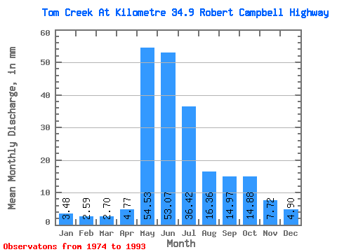
| Statistic | Jan | Feb | Mar | Apr | May | Jun | Jul | Aug | Sep | Oct | Nov | Dec | Annual |
|---|---|---|---|---|---|---|---|---|---|---|---|---|---|
| Mean | 3.48 | 2.62 | 2.70 | 4.77 | 54.52 | 53.06 | 36.41 | 16.36 | 14.98 | 14.87 | 7.72 | 4.90 | 216.59 |
| Standard Deviation | 1.40 | 0.98 | 1.05 | 1.96 | 24.95 | 35.96 | 25.83 | 6.67 | 5.17 | 7.20 | 3.21 | 2.13 | 80.37 |
| Min | 1.24 | 0.98 | 0.91 | 0.90 | 19.15 | 11.62 | 12.68 | 9.54 | 7.69 | 7.45 | 3.44 | 2.02 | 109.18 |
| Max | 6.34 | 4.45 | 4.48 | 7.99 | 131.13 | 170.42 | 102.81 | 30.10 | 31.88 | 35.89 | 16.80 | 9.54 | 387.34 |
| Coefficient of Variation | 0.40 | 0.37 | 0.39 | 0.41 | 0.46 | 0.68 | 0.71 | 0.41 | 0.34 | 0.48 | 0.42 | 0.44 | 0.37 |
 Return to R-Arctic Net Home Page