|
|
|||||||||||||||||
| Point ID: 5838 | Downloads | Plots | Site Data | Code: 09FD002 |
|
|
|||||||||||||||||
| Download | |
|---|---|
| Site Descriptor Information | Site Time Series Data |
| Link to all available data | |
| View: | Time Series | All |
| Units: | mm |
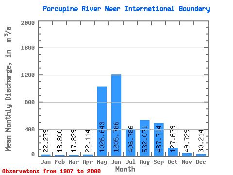
| Statistic | Jan | Feb | Mar | Apr | May | Jun | Jul | Aug | Sep | Oct | Nov | Dec | Annual |
|---|---|---|---|---|---|---|---|---|---|---|---|---|---|
| Mean | 22.28 | 18.80 | 17.83 | 22.11 | 1026.64 | 1205.79 | 406.79 | 532.07 | 487.71 | 127.68 | 49.73 | 30.21 | 328.97 |
| Standard Deviation | 3.63 | 3.75 | 3.38 | 9.33 | 547.03 | 509.01 | 221.74 | 205.54 | 193.14 | 45.16 | 15.12 | 5.03 | 71.69 |
| Min | 15.60 | 11.30 | 10.80 | 15.40 | 170.00 | 578.00 | 164.00 | 285.00 | 218.00 | 72.80 | 31.80 | 24.60 | 170.23 |
| Max | 28.10 | 24.20 | 24.10 | 48.40 | 1820.00 | 2450.00 | 834.00 | 1070.00 | 973.00 | 233.00 | 89.50 | 41.90 | 480.08 |
| Coefficient of Variation | 0.16 | 0.20 | 0.19 | 0.42 | 0.53 | 0.42 | 0.55 | 0.39 | 0.40 | 0.35 | 0.30 | 0.17 | 0.22 |
 Return to R-Arctic Net Home Page