|
|
|||||||||||||||||
| Point ID: 5838 | Downloads | Plots | Site Data | Code: 09FD002 |
|
|
|||||||||||||||||
| Download | |
|---|---|
| Site Descriptor Information | Site Time Series Data |
| Link to all available data | |
| View: | Time Series | All |
| Units: | m3/s |
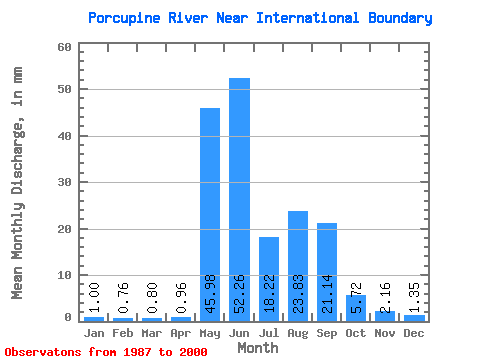
| Statistic | Jan | Feb | Mar | Apr | May | Jun | Jul | Aug | Sep | Oct | Nov | Dec | Annual |
|---|---|---|---|---|---|---|---|---|---|---|---|---|---|
| Mean | 1.00 | 0.77 | 0.80 | 0.96 | 45.98 | 52.26 | 18.22 | 23.83 | 21.14 | 5.72 | 2.15 | 1.35 | 173.62 |
| Standard Deviation | 0.16 | 0.15 | 0.15 | 0.40 | 24.50 | 22.06 | 9.93 | 9.21 | 8.37 | 2.02 | 0.66 | 0.23 | 37.84 |
| Min | 0.70 | 0.46 | 0.48 | 0.67 | 7.61 | 25.05 | 7.34 | 12.76 | 9.45 | 3.26 | 1.38 | 1.10 | 89.84 |
| Max | 1.26 | 0.99 | 1.08 | 2.10 | 81.50 | 106.19 | 37.35 | 47.92 | 42.17 | 10.43 | 3.88 | 1.88 | 253.37 |
| Coefficient of Variation | 0.16 | 0.20 | 0.19 | 0.42 | 0.53 | 0.42 | 0.55 | 0.39 | 0.40 | 0.35 | 0.30 | 0.17 | 0.22 |
 Return to R-Arctic Net Home Page